
Life without GPS seems almost unimaginable these days. It is used for personal navigation, commercial aviation, military operations, monitoring of crops and wildlife, and so much more. But are we being reckless by putting all of our eggs in one basket?
Today there are multiple satellite navigation systems such as Europe’s Galileo or China’s BeiDou, in addition to the original GPS constellation, but they all operate in a similar way with similar strengths and weaknesses. If these systems were hacked, jammed, or otherwise failed, there are no back up options. The disruption to so many critical operations would be catastrophic, costing some countries more than $1 billion USD a day.
«There is an urgent need to find an alternative robust and accurate navigation system to GPS,» says Zak Kassas, an associate professor at University of California, Irvine, and Director of US Department Transportation Center for Automated Vehicles Research with Multimodal AssurEd Navigation (CARMEN). «We are over-relying on these systems, despite their known limitations.»
Fortunately, Kassas and his colleagues have devised a novel substitute for GPS. Rather than relying on the small handful of GPS satellites circling in Earth’s higher orbits, his team is eyeing the more abundant and closer-to-home satellites in Earth’s low orbit, such as the Starlink fleet.
These satellites offer a number of advantages over GPS satellites. «They are about 20 times closer to Earth than GPS satellites, which means we receive their signals at considerably higher power than that of GPS. This makes them more difficult to jam or spoof and makes them reliable in environments where GPS signals are not,» explains Kassas.
He also notes that Starlink satellites, and others like them in Earth’s lower orbit, will «blanket» the planet once they are fully deployed, all the while transmitting multiple, high bandwidth signals that yield more accurate positioning results.
However, the broadband signals of Starlink satellites are considered intellectual property and are not publicly known, meaning that Kassas and his colleagues could not directly use these signals for tracking purposes. This prompted them to devise an alternative solution, which utilizes a receiver on the ground that tracks the phase of the underlying carrier wave emitted by a satellite. They developed an algorithm that calculates the ground receiver’s position, velocity, and time in relation to the unseen satellites above based on the carrier phase measurements.
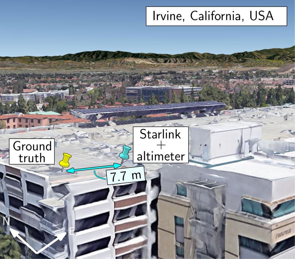
The true location and estimate of the location with Starlink satellites.Joe Khalife et al.
The researchers say they spent «countless hours» on the garage roof of their university building, testing the algorithm with different hardware configurations. In the spring of 2021, they successfully used six Starlink satellites to track their position accurately within just 7.7 meters. The results are described in a study published September 20 in IEEE Transactions on Aerospace and Electronic Systems, and was first reported by Ars Technica.
Notably, the researchers had to wait 800 seconds for all six Starlink satellites to pass over them, in order to attain the carrier phase measurements needed for their calculations during this first trial run. However, Kassas points out that thousands of additional satellites will be launched in the near future, which will likely result in a drastic improvement in real-time data availability and positioning accuracy. His team has also since improved upon their technique by developing a model that better detects carrier signals of satellites and estimates the user’s position using the Doppler effect of carrier signals from the low orbiting satellites.
A major question now is how this new approach compares to GPS. GPS systems are coupled with something called an inertial navigation system (INS). If a GPS signal is lost, this secondary system estimates a user’s position based on the anticipated trajectory. Kassas and his colleagues incorporated a similar INS approach with their low-orbit satellite tracking approach, calling it Simultaneous Tracking and Navigation (STAN). Next, they went for a joy ride on Orange County freeways to test STAN against a high-end GPS-INS.
During the 7 km drive, they cut their GPS signals during the last 2 km and compared the two navigation systems. The GPS-INS system accumulated an error of 202 meters without a GPS signal, whereas STAN accumulated an error of just 38 meters, while using three low-orbit satellites (Starlink, Orbcomm, and Iridium) to estimate the car’s position. These results show how STAN could yield more accurate positioning results when GPS signals fail.
Navigating the Streets By Starlink
youtu.be
«We achieved this feat with virtually no knowledge of what was being transmitted by Starlink satellites and with relatively inexpensive hardware,» emphasizes Kassas.
He says the group has filed for numerous national and international patents and is in the process of discussing commercializing the approach with several corporations. «Our current results are just uncovering what is possible,» says Kassas. «This is just the beginning.»
Source: IEEE Spectrum Telecom Channel