New analysis of the former Kakhovka Dam in Ukraine shows that it may have been deteriorating long before it collapsed in June 2023, amid credible reports of explosions.
An international team of researchers has been studying synthetic aperture radar (SAR) archival data of the dam and evaluating the larger context behind a deadly breach of the Dnieper river dam—whose collapse led to the death of between 59 and 300 people in the region. The researchers point out that, according to their analysis, the hydropower dam was showing signs of worrying subsidence months before it was captured by Russia in February 2022, when the country invaded Ukraine.
The team’s analysis also reveals other telltale movements in the dam that accelerated later that year, possibly due to poor maintenance by the occupying forces.
“We cannot say the Russians didn’t blow up the dam,” says Pietro Milillo, a professor of geosensing systems engineering at the University of Houston and one of the paper’s authors. “But we can say that there was something going on before. And if there was no maintenance going on, this could have been another cause of collapse.”
The new analysis of the Kakhova Dam leverages public SAR data that enables historic engineering analyses of infrastructure, even for structures that had not previously been suspected of failure. “I imagine a future where these kind of products are available in near real-time,” says Milillo. “You’ll have an engineer who can go into a control room for all the dams of an entire continent, and decide if something is going wrong.”
A mysterious explosion
In the early hours of 6 June last year, seismometers in Romania and Ukraine picked up large explosions near the Dnieper River in southern Ukraine. Witnesses near the Kakhova Dam reported blasts, and American intelligence satellites captured infrared radiation indicating an explosion.
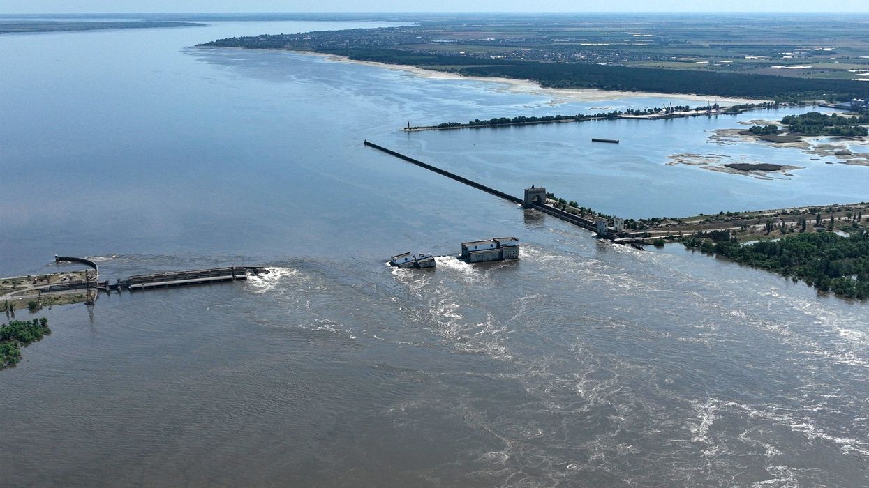
Water rushing from the dam burst downstream, devastating nearby towns and eventually flooding over 400 square kilometers. Officials in the Russian-controlled area put the death toll at 59, but Associated Press later quoted local health officials who estimated that the true figure was likely closer to 200 to 300 lives lost. Although both Russia and Ukraine denied causing an explosion at the dam, the New York Times and the AP found evidence that Moscow was likely responsible.
In the immediate aftermath of the collapse, commercial earth imaging satellites produced high resolution optical and radar images of the wreckage.
Synthetic aperture radar is an active sensor that detects the reflections of signals beamed from the satellite towards the Earth’s surface. Different materials have different electromagnetic signatures, and SAR signals are rarely affected by clouds or rain. This enables providers to quickly build up detailed surface maps.
Milillo and his colleagues used a high resolution SAR image from Santa Barbara, Calif.-based aerospace startup Umbra to identify which portions of the half-kilometer long dam had been breached. They then dove into public SAR data from two Sentinel-1 satellites operated by the European Space Agency.
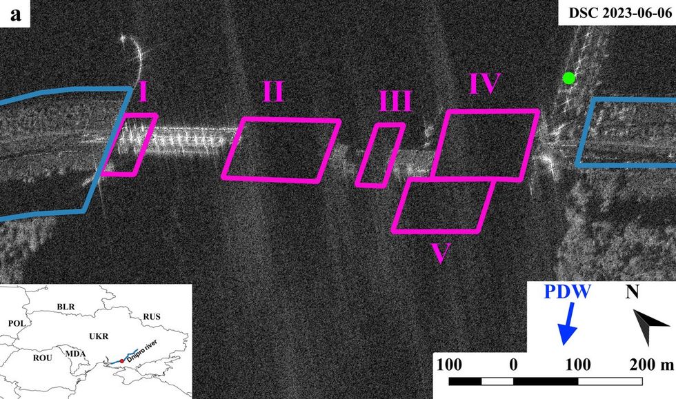
A high resolution synthetic aperture radar image of the Kakhova dam after its collapse highlights areas researchers concentrated on in their analysis of the disaster.SAR data: Umbra Lab; Figure: University of Houseton/DLR/TU Delft/Nature
Unlike the Umbra satellites, which only collect images for specific locations at specific times, Sentinel-1 satellites have been collecting SAR data of the entire planet since their launch about a decade ago. Each satellite revisits every point on the Earth’s surface about every 12 days.
Critically, and again unlike most commercial satellites, the Sentinel spacecraft collect information about the phase of the reflected radar signal, which can be used to measure distance to the target. When multiple observations of the same target are combined, a technique called multi-temporal interferometric synthetic aperture radar (MT-InSAR) allows researchers to measure millimeter-scale changes in topography and buildings.
Carl Pucci, CEO and founder of EO59, a Virginia Beach, Va.-based company specializing in MT-InSAR software and analytics, explains: “You can go back in time and see the accurate deformation of an infrastructure asset that may not ever have been instrumented.”
A history of data and movement
When Milillo’s team analyzed the archival Kakhova Dam images, they found the sections that were later breached, ranging from 50 to 150 meters in length, showed two significant changes in the preceding years. Starting in the summer of 2021, all began settling faster than before. One part of the dam started to subside at four times its previous rate.
When the Russians took control of Kakhova in early 2022, maintenance appears to have tailed off. Spillway gates used to control the level of the reservoir were not used, and water occasionally “overtopped” the dam itself.
Starting in the summer of 2022, Milillo’s analysis shows that two sections of the dam that later failed also began moving horizontally—bulging outwards by up to two centimeters a year. The paper says this structural distress could have been caused by a lack of maintenance, faulty gate operation, and the accumulation of sediment and debris at the dam’s foundations.
“The interesting part is that these deformations don’t occur the same way everywhere along this dam,” says Milillo. “It happens only in these few hotspots that we were able to identify with the Umbra and Sentinel-1 data.”
The rest of the dam showed little dramatic movement in the years leading up to the collapse—just the usual slow subsidence of a nearly 70-year old Soviet-era dam. The last Sentinel-1 data from the intact dam were captured on June 1, and showed no large changes.
No firm conclusions
Milillo cautions that his analysis does not determine whether or not the Russians sabotaged the dam with a bomb, or doomed it by neglecting essential repairs.
“The next step is to get structural engineers to look at this data and make sense of them,” he says. “A finite element model might allow us to get more insight on the cause of the collapse.”
Whatever caused the Kakhova Dam to fail, Milillo believes the analytic power of satellite MT-InSAR could help secure the remaining 35,000 large dams in the world: “With this technology, we could get a complete picture of deformation of every dam almost every week, to add a further layer of security and safety.”
Pucci agrees. Since 2022, EO59 has been using MT-InSAR to monitor a levee in Russian-occupied Ukraine that is in danger of releasing toxic chemicals into the Sea of Azov. “How do we figure out what is happening to Ukraine’s dams, rail lines, bridges, and nuclear facilities behind enemy lines or taking fire?” he asks. “MT-InSAR is going to be critical to the rebuilding of the country.”
Source: IEEE Spectrum Telecom Channel